File:Radar Tower coverage comparison.png
Jump to navigation
Jump to search

No higher resolution available.
Radar_Tower_coverage_comparison.png (373 × 564 pixels, file size: 206 KB, MIME type: image/png)
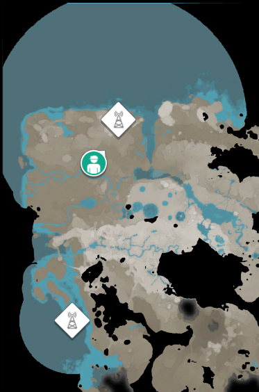
Circular areas revealed by Radar Towers: one on the Rock Spire, the other at Oil Islands at sea level. Observe their coverage differences.
Licensing
| This file (or parts of it) comes from Satisfactory (data files or gameplay), from websites, or from any other content created and owned by Coffee Stain Studios, who hold the copyright of Satisfactory. Unless specified otherwise, all trademarks and registered trademarks present in the image are proprietary to Coffee Stain Studios. For more information, see the copyright notice. The use of images to illustrate articles concerning the subject of the images in question is believed to qualify as fair use under United States copyright law, as such display does not significantly impede the right of the copyright holder to sell the copyrighted material. |
File history
Click on a date/time to view the file as it appeared at that time.
| Date/Time | Thumbnail | Dimensions | User | Comment | |
|---|---|---|---|---|---|
| current | 16:55, 18 March 2023 | | 373 × 564 (206 KB) | Kwjcool321 (talk | contribs) |
You cannot overwrite this file.
File usage
The following 2 pages use this file: